
Plaidwerx


Features: Scottish Parishes » Historic Shires » Argyllshire » Lochgilphead

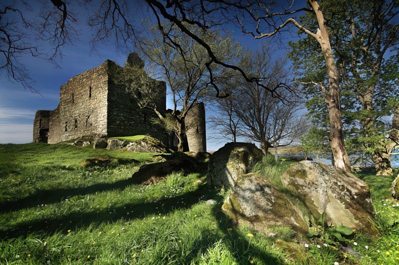
Castle Sween by Mike138
Castle Sween, Lochgilphead © 2007, mike138

LOCHGILPHEAD PARISH

TABLE OF CONTENTS


LOCATION

Location Description:

A village, and lately a quoad sacra parish, partly in the parish of South Knapdale, but chiefly in that of Kilmichael-Glassary, district and county of Argyll, 24 miles (S. W.) from Inverary. (1846: Topographical Dictionary of Scotland, by Samuel Lewis)

Shire, District, and Region Timeline:

  • Shire: Argyllshire (Before 1707)
  • County: Argyll (After 1707)
  • District: Argyle (Before 1930)
  • Landward District: Mid Argyll (1930-1975)
  • Region: Strathclyde (1975-1996)
  • Sub-Region: Argyll (1975-1996)
  • District: Argyll and Bute (1975-1996)

Burghs:

  • Name: Lochgilphead
  • Police Burgh (1858)
  • Small Burgh (1929)
  • Burgh system abolished (1975-1996)

Cities, Towns, Villages, and Hamlets:

Ardfern


PARISH TIMELINE

PRE-REFORMATION GOVERNANCE:

  • Diocese: Argyll
  • Deanery: Glassary

POST-REFORMATION GOVERNANCE:

  • Synod: Argyll
  • Presbytery: Inveraray

PAROCHIAL OVERVIEW:

A parliamentary church was built here in 1828. The parish of Lochgilphead was disjoined from Glassary and South Knapdale on 4 March 1846. Near the head of Loch Gilp there were of old chapels of St Mary and St Bride.

Disjoined Quoad Sacra Parishes:
Ardrishaig. A church, built on a site granted by the Commissioners of the Crinan Canal, was opened in March 1860, and was served for a time by the Royal Bounty Missionaries. The parish was disjoined from Lochgilphead and South Knapdale, 1 March 1875.

CHURCH OF SCOTLAND CLERGY:

Includes ministers, licentiates, assistants, readers, and clerks.

Lochgilphead (QO)

  • Peter MacKichan, 1828
  • Donald Jackson, 1843
  • John Stewart, 1857
  • Peter Neil MacKichan, 1863
  • Alexander Cameron Robertson, 1876

Ardrishaig (QS)

  • Donald MacLachlan, 1853
  • John MacKinlay, 1855
  • Hugh MacAlpine, 1856
  • Joseph M'Innes, 1857
  • Neil MacDougall, 1862
  • Archibald Campbell, 1864
  • Peter Morrison, 1866
  • Duncan MacDonald, 1870
  • Angus MacPhee, 1872
  • Donald MacEchern, 1876
  • Malcolm M'Coll, 1880
  • Coll Archibald MacDonald, 1901
  • Kenneth M'Lean, 1907
  • John M'Rorie Kay, 1918
  • John Paul Glen, 1920

(1928: Fasti Ecclesiæ Scoticanæ, by Hew Scott, D. D.)


RECORDS

Parochial Registers:

Parish registers turned over to the Registrar-General, as a result of the Registration of Births, Deaths, and Marriages (Scotland) Act of 1854. The letters B. D. and M. indicate Births (or Baptisms), Deaths (or Burials), and Marriages (or Proclamations of Banns) respectively. Numbers indicate separate volumes or books. Note: These records are by no means complete or without damage; consult the Detailed List of the Old Parochial Registers of Scotland (1872) to learn more about the condition of the records.

  • No Old Parochial Records

OPR and RD Numbers
Date RangeNameNumberType
1846-1854Lochgilphead526OPR
1855-1971Lochgilphead526RD
1972-2006Lochgilphead533RD
2009Argyll and Bute, Lochgilphead533RD
2026Argyll and Bute Council; Lochgilphead Community Council

(2009: Parishes and Registration Districts of Scotland - Old and New, National Records of Scotland)

Local community councils (2026) are provided as a potential source of additional information for settlements within the original boundaries of the parish. (Source)

Population:

Statistics from informal and official censuses

  • 1861: 3,312
  • 1901: 3,770
  • 1911: 3,156

RESIDENTS


Common Surnames:

Bell, Boden, Boyd, Campbell, Crawford, Fletcher, Greer, Johnston, Simson, Weir


NOTES:

See Parish Page Sources for all source information and links.
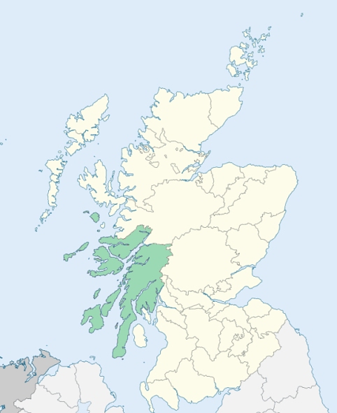

Photo credits: (Featured) Castle Sween, Lochgilphead, © 2022 mike138, used under Creative Commons License CC BY-ND 2.0, (Related Resources) Argyllshire Locator Map, © 2005, Owen Blacker, used under Creative Commons License CC BY-SA 4.0.
Related Resources
Map of Scotland with Argyllshire highlighted
Location of Argyllshire
See more maps at Wikimedia Commons
Glossary
  • Burghs:
  • Royal - Towns on royal lands
  • Regality - Towns granted to noblemen/landowners
  • Barony - Towns granted to tenant-in-chief (laird)
  • Police - Towns with elected officials
  • Small - Population under 20,000
  • Large - Population over 20,000
  •  
  • Chapel-of-Ease: Small church for those living far from the main church
  • Collegiate church: See What is a Collegiate Church?
  • Commune kirk: Owned by a larger church
  • Court of Teinds: Controlled funds for support of clergy
  •  
  • Friars:
  • Black - Dominican
  • Grey - Franciscan
  • Red - Trinitarian
  • White - Carmelite
  •  
  • Iron chapel: Building made of corrugated galvanized iron
  •  
  • Landward District: Rural part of a district
  •  
  • Mensal: Source of income to support clergy member (Roman Catholic)
  •  
  • OPR: Old Parochial Register
  •  
  • Pre-Reformation: Before 1560
  • Prebend: Source of income to support a clergy member
  •  
  • QO: Quoad Omnia - Civil and church control
  • QS: Quoad Sacra - Church control only
  •  
  • RD: Registration District - Civil control
  •  
  • Tryst: Large-scale market or fair, particularly for livestock
  •