Kilspindie and Rait
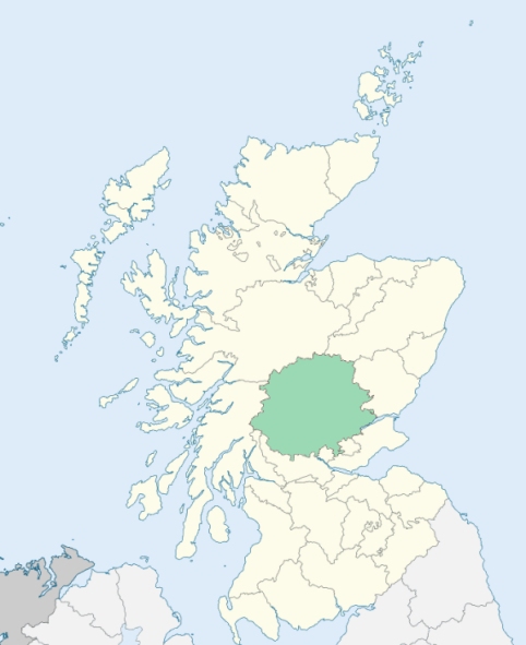
Kilspindie is a parish in the Gowrie district of southeast Perthshire. It is bounded on the north by the parish of Collace; on the northeast by Kinnaird; on the east and southeast by Errol; on the south by Kinfauns; on the southeast by Kinnoull; on the west by Scone; and on the northwest by St Martins. (1892-6: Ordnance Gazetteer of Scotland, by Francis H. Groome)
Kilspindie, Rait
PRE-REFORMATION GOVERNANCE:
POST-REFORMATION GOVERNANCE:
The parishes of Kilspindie and Rait were united before 1620.
Kilspindie. The church of Kilspindie was dedicated to St Pansandus. It belonged to the Abbey of Scone.
Rait. The church of Rait was dedicated to St Peter. It belonged to the Abbey of Scone. There was in the parish a Well of St Peter.
Includes ministers, licentiates, assistants, readers, and clerks.
Kilspindie (QO)
Rait (QO)
(1928: Fasti Ecclesiæ Scoticanæ, by Hew Scott, D. D.)
Parish registers turned over to the Registrar-General, as a result of the Registration of Births, Deaths, and Marriages (Scotland) Act of 1854. The letters B. D. and M. indicate Births (or Baptisms), Deaths (or Burials), and Marriages (or Proclamations of Banns) respectively. Numbers indicate separate volumes or books. Note: These records are by no means complete or without damage; consult the Detailed List of the Old Parochial Registers of Scotland (1872) to learn more about the condition of the records.
| OPR and RD Numbers | |||
|---|---|---|---|
| Date Range | Name | Number | Type |
| 1656-1854 | Kilspinde | 363 | OPR |
| 1855-1958 | Kilspindie | 363 | RD |
| 2009 | Perth and Kinross, Perth | 390 | RD |
| 2026 | Perth and Kinross Council; Inchture Community Council | ||
(2009: Parishes and Registration Districts of Scotland - Old and New, National Records of Scotland)
Local community councils (2026) are provided as a potential source of additional information for settlements within the original boundaries of the parish. (Source)
Statistics from informal and official censuses
Anderson, Brough, Brown, Coyne, Miller, Robertson, Stewart, Thom, Watson, Wilson
Note: Names appearing in research materials, other than censuses. Simple names (First name, surname only) have been omitted unless they appear associated with large properties. All women's names, and men's names with occupations, military ranks, or peerage titles are included.
By the Reverend Mr Anthony Dow.
"The number of souls in August 1789 was 718. Males 340, females 378. In one village are 170, and in another 60 souls. There are 68 souls under 10 years of age, only 1 above 90. There are 15 farmers, employing each 2 ploughs, or more; 7 or 8 smaller farmers, who have only 1 plough; 45 weavers, all employed in making sale linen, commonly coarse; they all work for some manufacturer, either in Perth or Dundee; 4 blacksmiths with 4 apprentices, 3 shoemakers with 1 apprentice, 4 house and cart wrights with 2 apprentices, 4 tailors, 6 meal-millers at as many different mills, 2 masons, 3 gardeners, 2 distilleries employing 5 men, not above 8 or 10 household servants, and 111 labouring servants, male and female.
14 families are Seceders (Burghers and Antiburghers), 2 or 3 Episcopalian Nonjurants, who all now attend in the Established Church, only 1 Roman Catholic, 65 bachelors above 21 years of age. There are 149 inhabited houses, and only 2 uninhabited houses.
The vulgar in most part of this country, and particularly here, have an utter dislike to all regular physicians and surgeons, though in general, their faith in drugs, quack medicines, and old wives nostrums, is most implicit. Common people are in general rather tall, strong and clumsy in person; dull, obstinate, rude and unmannerly, fond of dress to an extreme, live well. The better sort of farmers, luxurious and expensive in their mode of living, without the least claim to neatness or elegance."
(This section contains excerpts, at times restructured or paraphrased, from an article appearing in Statistical Account of Scotland, Sir John Sinclair, 1791-1799)
Primary Sources:
Statistical Account of Scotland (1791-1799), Volume 4, p. 202
New Statistical Account of Scotland (1834-1845), Volume 10, p. 1162
See Parish Page Sources for all source information and links.