Helmsdale
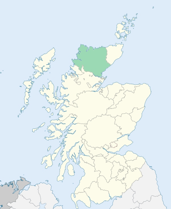
Kildonan is a parish in the north-east of Sutherlandshire. It is bounded by Caithness-shire, the German Ocean (North Sea), and the parishes of Loth, Clyne, Farr, and Reay. (1867: The Imperial Gazetteer of Scotland, by John Marius Wilson).
Helmsdale, Kilmuir, Kilpheadair, Kinbrace, Strathuilie
PRE-REFORMATION GOVERNANCE:
POST-REFORMATION GOVERNANCE:
The church of Kildonan was dedicated to St Donan. In the Cathedral of Dornoch there was a prebend of Kildonan. When the Presbytery of Tongue was erected, on 11 May 1726, the parish of Kildonan was taken from the jurisdiction of Dornoch, and assigned to that of Tongue. On 18 May 1727, the General Assembly again annexed Kildonan to the Presbytery of Dornoch. There were two chapels within the bounds, St Peter's at Kilpheadair, and St Mary's at Kilmuir. There was in the parish a Well of St John the Baptist. There are two mission chapels in this parish, that of St Donan at the Kirkton of Kildonan in Strathuilie, and the other at Kinbrace. At the time of the Sutherland Clearances many Kildonan people emigrated to the Selkirk colony at Manitoba (now a historical district within the city of Winnipeg, Canada), where they named their settlement Kildonan, and erected a church, a replica of that in which they had worshipped at home.
Includes ministers, licentiates, assistants, readers, and clerks.
(1928: Fasti Ecclesiæ Scoticanæ, by Hew Scott, D. D.)
Parish registers turned over to the Registrar-General, as a result of the Registration of Births, Deaths, and Marriages (Scotland) Act of 1854. The letters B. D. and M. indicate Births (or Baptisms), Deaths (or Burials), and Marriages (or Proclamations of Banns) respectively. Numbers indicate separate volumes or books. Note: These records are by no means complete or without damage; consult the Detailed List of the Old Parochial Registers of Scotland (1872) to learn more about the condition of the records.
| OPR and RD Numbers | |||
|---|---|---|---|
| Date Range | Name | Number | Type |
| 1790-1854 | Kildonan | 52 | OPR |
| 1855-1967 | Kildonan | 52 | RD |
| 1968-1971 | Helmsdale | 52 | RD |
| 1972-2006 | Helmsdale | 176 | RD |
| 2009 | Highland, Helmsdale | 176 | RD |
| 2026 | Highland Council; Helmsdale Community Council | ||
(2009: Parishes and Registration Districts of Scotland - Old and New, National Records of Scotland)
Local community councils (2026) are provided as a potential source of additional information for settlements within the original boundaries of the parish. (Source)
Statistics from informal and official censuses
Bannerman, Bruce, Fraser, Gordon, Gunn, Matheson, Murray, Polson, Ross, Sutherland
Note: Names appearing in research materials, other than censuses. Simple names (First name, surname only) have been omitted unless they appear associated with large properties. All women's names, and men's names with occupations, military ranks, or peerage titles are included.
By the Reverend Mr Alexander Sage.
"In April 1791, the population amounted to 1365, of whom 244 were men, 295 women, 756 children, and 70 servants. There are only 2 old men, the one 80, and the other 96 years of age. The language spoken in this parish is Gaelic, and the greatest number of the names of places is of Gaelic extraction. There is as yet no proper house of accommodation for strangers in the parish. There are, indeed, 8 whisky houses, in which much tippling is carried on, and of consequence, several immoral practices have been thereby introduced among the people. But as there is no regular inn, travelers above the common rank cannot be accommodated, unless they lodge in the minister's house. In the lower part of the parish, the people, in favourable years, can raise crops, which not only supply themselves with provisions, but enable them to dispose of bear (barley), oat meal, and potatoes, for seed to the Highlanders in the heights of the district, where the lands are bad, and more subject to blasting and mildew."
(This section contains excerpts, at times restructured or paraphrased, from an article appearing in Statistical Account of Scotland, Sir John Sinclair, 1791-1799)
Primary Sources:
Statistical Account of Scotland (1791-1799), Volume 3, p. 405
New Statistical Account of Scotland (1834-1845), Volume 15, Section I, p. 133
See Parish Page Sources for all source information and links.