Kilmalie, Kilmalin, Colmalie, Culmalin
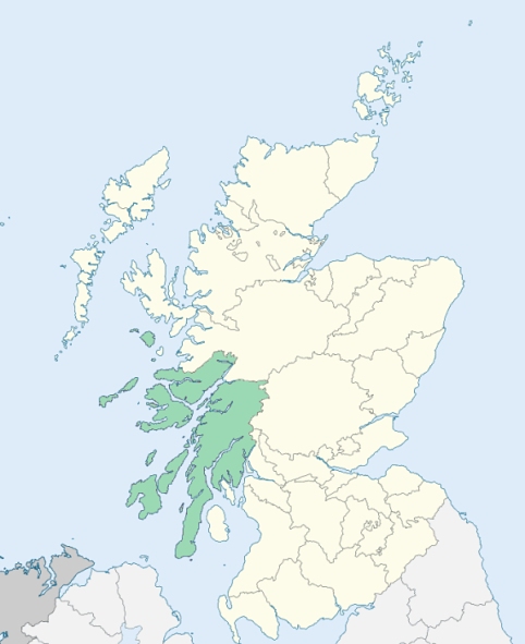
Kilmallie is a Highland parish, partly in Inverness-shire and partly in Argyleshire. It is bounded on the south-east by Perthshire, and on other sides by the parishes of Appin, Morven, Ardnamurchan, Glenelg, and Kilmanivaig. (1867: The Imperial Gazetteer of Scotland, by John Marius Wilson).
Achintore, Achluachrach, Achphubil, Banavie, Blaich, Bohunton, Corpach, Corrybeg, Drimarbane, Duisky, Fort William, Gairlochy, Garvan, Kingairloch, Lochyside, Muishirlich, Onich
Achnacarry, Fassifern, Glensanda
(1) This parish was divided between the counties of Argyll and Inverness by a boundary which, traversing the district situated north of Loch Eil and south of Loch Arkaig, was exceedingly irregular and inconvenient. Loch Eil was made the new county boundary, and the portion of Kilmallie north of Loch Eil so far as previously in Argyllshire was transferred to Inverness-shire. See details. (1892: Boundary of counties and parishes in Scotland as settled by the Boundary Commissioners under the Local Government Act, 1889, by Hay Shennan)
(2) The parish of Lismore and Appin had a detached part situated at Kingairloch on the north side of Loch Linnhe. This detached part was transferred to the parish of Kilmallie. See details. (1892: Boundary of counties and parishes in Scotland as settled by the Boundary Commissioners under the Local Government Act, 1889, by Hay Shennan)
(3) Part of the parish of Kilmallie was separated from the remainder by a small intervening portion of Kilmonivaig. This intervening portion of Kilmonivaig has been transferred to Kilmallie. The part so transferred is situated on Loch Linnhe between the River Lochy and the River Nevis, and is bounded on the east by the march of Mrs. Cameron Campbell's property. See affected properties and landholders. (1892: Boundary of counties and parishes in Scotland as settled by the Boundary Commissioners under the Local Government Act, 1889, by Hay Shennan)
PRE-REFORMATION GOVERNANCE:
POST-REFORMATION GOVERNANCE:
The church of Kilmallie was dedicated to St Mailin of Teach Malin in Carlow. In early times the parish was styled Kilmalin. On Eilean Cholumcill, an island in Loch Arkaig, there was a chapel of St Columba. A fair of St Mary was held at Kilmallie on Assumption Day in August. There is now in the parish a mission chapel on Loch Arkaig. The civil parish is the largest in Scotland. The church was vacant from the Reformation until 1651.
Disjoined Quoad Sacra Parishes:
Duncansburgh, previously Inverlochy and Fort William. The parish of Duncansburgh was disjoined from Kilmallie, 18 July 1860. At Inverlochy, within the bounds, there was a Well of St Michael.
Includes ministers, licentiates, assistants, readers, and clerks.
Kilmallie (QO)
Duncansburgh, or Inverlochy and Ft William (QS)
(1928: Fasti Ecclesiæ Scoticanæ, by Hew Scott, D. D.)
Parish registers turned over to the Registrar-General, as a result of the Registration of Births, Deaths, and Marriages (Scotland) Act of 1854. The letters B. D. and M. indicate Births (or Baptisms), Deaths (or Burials), and Marriages (or Proclamations of Banns) respectively. Numbers indicate separate volumes or books. Note: These records are by no means complete or without damage; consult the Detailed List of the Old Parochial Registers of Scotland (1872) to learn more about the condition of the records.
| OPR and RD Numbers | |||
|---|---|---|---|
| Date Range | Name | Number | Type |
| 1773-1854 | Kilmallie | 520 | OPR |
| 1855-1910 | Kilmallie | 520 | RD |
| 1911-1927 | Kilmallie | 98b | RD |
| 1928-1970 | Kilmallie | 98b-1 | RD |
| 2009 | Highland, Fort William and Ballachulish | 239 | RD |
| 2026 | Highland Council; Kilmallie Community Council | ||
(2009: Parishes and Registration Districts of Scotland - Old and New, National Records of Scotland)
Local community councils (2026) are provided as a potential source of additional information for settlements within the original boundaries of the parish. (Source)
Statistics from informal and official censuses
Boyd, Cameron, Campbell, Fraser, Kennedy, MacDonald, MacIntyre, Rankin, Stewart, Young
Note: Names appearing in research materials, other than censuses. Simple names (First name, surname only) have been omitted unless they appear associated with large properties. All women's names, and men's names with occupations, military ranks, or peerage titles are included.
By the Reverend Mr Alexander Fraser, Minister of the Parish.
"By the most exact calculation, the number of souls is 4225. Of the above number, about 1200 live in Maryburgh and Fort William; and of these there are 2 merchants, 9 shopkeepers, 11 carpenters, 1 ship-wright, 3 boat-wrights, 3 wheel-wrights, 2 cart-wrights, 2 coopers, 6 sawyers, 26 masons, 12 tailors, 24 weavers, 18 shoemakers, 3 smiths, 3 nailers, 3 butchers, 3 bakers, 2 fiddlers, 1 barber, 1 dyer, 3 surgeons, 10 farmers, 4 gardeners, 2 innkeepers, 5 mantua-makers, and 4 seamstresses.
The Gaelic is the mother tongue of the natives; and, it is thought, that in this, and some neighbouring parishes, it is spoken in its greatest purity. Though the Gaelic be the original language, there are very few people, especially of the younger class, who do not understand and speak English. It is remarkable, yet not the less true, that the illiterate Highlander, who is a stranger to every other language but the Gaelic, speaks it more fluently, more elegantly, and more purely, than the scholar."
(This section contains excerpts, at times restructured or paraphrased, from an article appearing in Statistical Account of Scotland, Sir John Sinclair, 1791-1799)
Primary Sources:
Statistical Account of Scotland (1791-1799), Volume 8, p. 407
New Statistical Account of Scotland (1834-1845), Volume 14, Section I, p. 117
See Parish Page Sources for all source information and links.