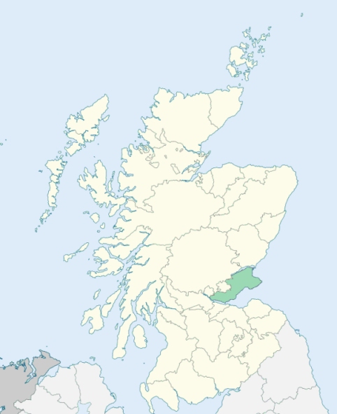
Dunfermline is a parish in the south-west of Fifeshire. The portion containing the village of North Queensferry lies 2¼ miles south-south-east of the nearest part of the rest of the parish, and is a modern annexation formerly belonging to Inverkeithing. It is bounded on the south by Firth of Forth and by Inverkeithing, on the east by Inverkeithing, Aberdour, Dalgety, and Beath, on the north by Kinross-shire, and on the west by Saline, Carnock, and Torryburn. (1867: The Imperial Gazetteer of Scotland, by John Marius Wilson).
Blackburn, Bowershall, Brucefield, Charleston or Charlestown, Crossford, Crossgates, Dunfermline, Halbeath, Kingseat, Limekilns, Masterton, Middledean, Milesmark, North Queensferry, Parknook, Pattiesmuir, Roscobie, Townhill, Wellwood
Appin, Balmule, Broomhall or West Gellet, Pitfirrane, Pitreavie, Pittencrieff
Whereas a part of the parish of Dunfermline, forming a portion of the estate of Moreland, is situated or alleged to be situated in the county of Kinross, the rest of the said parish being situated in the county of Fife:
And whereas a part of the parish of Dunfermline, situated at or near North Queensferry and lying to the south of the parish of Inverkeithing, is detached from the main portion of the parish of Dunfermline:
And whereas a part of the parish of Inverkeithing, situated at or near Milesmark and almost surrounded by the parish of Dunfermline, is detached from the main portion of the said parish of Inverkeithing:
I. So much of the parish of Dunfermline as lies to the north of the south march of the estate of Moreland shall form part of the parish of Cleish and of the county of Kinross.
II. The aforesaid detached part of the parish of Dunfermline shall cease to be part of that parish, and shall form part of the parish of Inverkeithing.
III. The aforesaid detached part of the parish of Inverkeithing, and so much of the parish of Inverkeithing as lies to the west of the east march of the farm of Brucehaven (otherwise called Claysikes), shall cease to be part of the parish of Inverkeithing, and shall form part of the parish of Dunfermline.
See affected properties and landholders. (1892: Boundary of counties and parishes in Scotland as settled by the Boundary Commissioners under the Local Government Act, 1889, by Hay Shennan)
PRE-REFORMATION GOVERNANCE:
POST-REFORMATION GOVERNANCE:
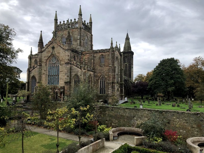
The ancient church of this parish formed the west portion of the Abbey Church, the east part being reserved for the monks; but there is no reference to the parish church of Dunfermline as Parish Church before 1300-1301. From about 1306 (and in all likelihood earlier still) the Abbey Church was described as the Church of the Holy Trinity and St Margaret. Within the bounds of the parish were the following chapels: St Ninian's, St Katherine the Virgin's, St Mary's at Nethertown, and St John the Baptist's at Garvoch. There were also St Leonard's Chapel and Hospital. Probably about 1072-74 Queen Margaret and Malcolm III built a church, dedicated to the Holy Trinity, and in all likelihood on the site of an earlier foundation. In or soon after 1124 David I erected the Benedictine Priory of Dunfermline into an Abbey. At the same time he built a new church. In 1593 the Abbey church was repaired and fitted up to be the parish church of Dunfermline. During a winter gale, in 1672, part of the east end of the building was blown down. In 1716 the central tower fell, causing much damage. In 1807 the south-western tower was shattered by lightning. The tower was rebuilt in 1810. There are mission chapels in this parish at Townhill and Steelend.
Disjoined Quoad Sacra Parishes:
Mossgreen. A church was built in 1852 and enlarged in 1877. Mossgreen became a chapel-of-ease in 1860. The parish was disjoined from Aberdour, Dalgety, Inverkeithing, and Dunfermline, 13 January 1879.
North Parish. The North Church (Golfdrum), founded early in 1840, was opened for public worship on the second Sunday of November 1840. This parish was erected quoad sacra 24 Jan 1855.
St Andrew's. This parish was granted a constitution in terms of the Act of Assembly on 31 May 1834, called St Andrew's, and erected quoad sacra by the Court of Teinds, 11 June 1851.
St Leonard's. Under the designation of the Brucefield Mission, work was inaugurated and carried on in a temporary church in the Brucefield district of Dunfermline. William M'Laren, Dunfermline, bequeathed a sum of money for the erection of a church and hall at Brucefield, and on 17 September 1904 the church was opened for worship. A Chapel-of-Ease constitution was obtained in the same year. St Leonard's parish was erected on 24 January 1908. At what is now the entrance to the Brucefield property stood the chapel and hospital of St Leonard, erected probably in the thirteenth century.
(1928: Fasti Ecclesiæ Scoticanæ, by Hew Scott, D. D.)
Includes ministers, licentiates, assistants, readers, and clerks.
Dunfermline (QO)
Mossgreen (QS)
North Parish (QS)
St Andrew's (QS)
St Leonard's (QS)
(1928: Fasti Ecclesiæ Scoticanæ, by Hew Scott, D. D.)
Parish registers turned over to the Registrar-General, as a result of the Registration of Births, Deaths, and Marriages (Scotland) Act of 1854. The letters B. D. and M. indicate Births (or Baptisms), Deaths (or Burials), and Marriages (or Proclamations of Banns) respectively. Numbers indicate separate volumes or books. Note: These records are by no means complete or without damage; consult the Detailed List of the Old Parochial Registers of Scotland (1872) to learn more about the condition of the records.
| OPR and RD Numbers | |||
|---|---|---|---|
| Date Range | Name | Number | Type |
| 1561-1854 | Dunfermline | 424 | OPR |
| 1855-1877 | Dunfermline Burgh | 424-1 | RD |
| 1855-1877 | Dunfermline Landward | 424-2 | RD |
| 1878-1971 | Dunfermline | 424 | RD |
| 1972-2002 | Dunfermline | 432 | RD |
| 2003-2006 | Dunfermline | 432-434 | RD |
| 2009 | Fife, Dunfermline | 432-434 | RD |
| 2026 | Fife Council; Abbeyview Community Council Bellyeoman Community Council Headwell Community Council Izatt Avenue Area and Netheron Community Council South Dunfermline Community Council Touch and Garvock Community Council Wellwood Community Council | ||
(2009: Parishes and Registration Districts of Scotland - Old and New, National Records of Scotland)
Local community councils (2026) are provided as a potential source of additional information for settlements within the original boundaries of the parish. (Source)
Statistics from informal and official censuses
Allan, Anderson, Beveridge, Brown, Campbell, Henderson, Hunter, Robertson, Thomson, Wilson
Note: Names appearing in research materials, other than censuses. Simple names (First name, surname only) have been omitted unless they appear associated with large properties. All women's names, and men's names with occupations, military ranks, or peerage titles are included.
By the Reverend Mr Allan MacLean, and the Reverend Mr John Fernie.
"The population in 1791-2 was 9550 souls, of whom 4740 were males, and 4810 were females; 2481 were under 10 years of age. There were 2131 families. There were 5192 inhabitants in the neighbouring towns and suburbs of Pittencrieff, 658 in the village of Limekilns, and 487 in the village of Charlestown.
In the parish there are 2 physicians, 4 surgeons, 15 merchants, 7 writers, 21 manufacturers, 43 shopkeepers, 10 brewers, 1 distiller, 50 smiths, 96 wrights, 862 weavers, 93 tailors, 54 shoemakers, 37 masons, 29 bakers, 13 fleshers, 11 gardeners, 109 sailors, 184 colliers, 101 ale sellers, 400 male servants, and 300 female servants employed in husbandry.
At the coal mines of this parish there are about 180 colliers, 140 bearers, 300 persons above ground repairing roads, driving and shipping coals, & and 400 women and children, who occasionally work, and are supported by the mines. Total, 1020 employed and supported.
There are 8 villages in the parish. The populous villages of Limekilns and Charlestown are pleasantly situated on the coast of the Firth of Forth. Crossford, Halbeath, and Crossgates are situated on the great turnpike road; Mastertown, Pettimuir, and Pitliver are situated on the southern division of the parish.
The government of the borough is lodged in a council of 22, consisting of 12 guildry or merchant-councillors, 8 deacons of incorporations (smiths, wrights, weavers, tailors, shoemakers, masons, bakers, and fleshers), and 2 trades-councillors; the magistrates are a provost, 2 baillies, and dean of guild.
The language is a mixture of Scotch and English. The voice is raised, and the emphasis frequently laid on the last word of the sentence. In general, the people are strong, and abundantly quick in learning mechanical employments. Many are remarkably ingenious, industrious, and frugal. Such persons enjoy the necessaries and comforts of life, and are happy in their present situation. It must be acknowledged, that there are also many idle, factious, discontented persons, who are greatly divided in the political, moral, and religious sentiments. Education is too often neglected. Many cannot read. Many come to the parish, and go from it, whose characters are never attested."
(This section contains excerpts, at times restructured or paraphrased, from an article appearing in Statistical Account of Scotland, Sir John Sinclair, 1791-1799)
Primary Sources:
Statistical Account of Scotland (1791-1799), Volume 13, p. 428
New Statistical Account of Scotland (1834-1845), Volume 9, Section I, p. 821
See Parish Page Sources for all source information and links.