Durris
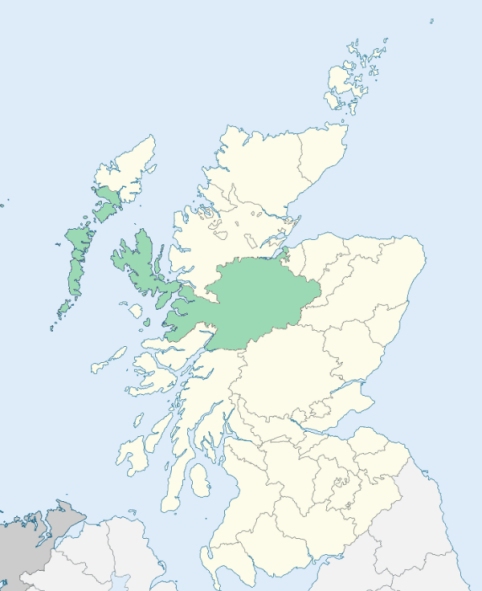
Dores is a parish in Inverness-shire. It is bounded on the north-west side by Loch Ness, and on other sides by the parishes of Inverness, Daviot, and Boleskine.(1867: The Imperial Gazetteer of Scotland, by John Marius Wilson).
Aultnagoire, Balnafoich, Gortlech or Gorthlick, Dores, Torness
Ness
The parish of Boleskine & Abertarff had a detached part extending to 1,367 acres, and lying to the east of Loch Farraline and of the parish of Dores. The parish of Dores, on the other hand, had two detached parts, the one nearly and the other wholly surrounded by the parish of Boleskine & Abertarff. Dores detached No. 1 was situated south of Foyers and abutted on Loch Ness. Dores detached No. 2 lay south of Loch Killin and east of the River Killin. These parishes were made to exchange their detached parts. The detached part of Boleskine & Abertarff was transferred to Dores and the two detached parts of Dores were transferred to Boleskine & Abertarff. See affected properties and landholders. (1892: Boundary of counties and parishes in Scotland as settled by the Boundary Commissioners under the Local Government Act, 1889, by Hay Shennan)
PRE-REFORMATION GOVERNANCE:
POST-REFORMATION GOVERNANCE:
The parsonage of Dores was held by the Abbey of Pluscarden.
Includes ministers, licentiates, assistants, readers, and clerks.
(1928: Fasti Ecclesiæ Scoticanæ, by Hew Scott, D. D.)
Parish registers turned over to the Registrar-General, as a result of the Registration of Births, Deaths, and Marriages (Scotland) Act of 1854. The letters B. D. and M. indicate Births (or Baptisms), Deaths (or Burials), and Marriages (or Proclamations of Banns) respectively. Numbers indicate separate volumes or books. Note: These records are by no means complete or without damage; consult the Detailed List of the Old Parochial Registers of Scotland (1872) to learn more about the condition of the records.
| OPR and RD Numbers | |||
|---|---|---|---|
| Date Range | Name | Number | Type |
| 1734-1854 | Dores | 96a | OPR |
| 1766-1854 | Duthil and Rothiemurchus | 96b | OPR |
| 1855-1869 | Dores | 96 | RD |
| 1870-1970 | Dores | 96a | RD |
| 1870-1970 | Duthil | 96b1 | RD |
| 1870-1970 | Rothiemurchus | 96b2 | RD |
| 1971-1971 | Aviemore | 96 | RD |
| 1972-2006 | Aviemore | 233 | RD |
| 2009 | Highland, Aviemore | 233 | RD |
| 2026 | (Dores) Highland Council; Dores and Essich Community Council | ||
| 2026 | (Duthil) Moray Council; Speyside Community Council | ||
| 2026 | (Rothiemurchus) Moray Council; Aviemore & Vicinity Community Council | ||
| 2026 | (Aviemore) Moray Council; Aviemore & Vicinity Community Council | ||
(2009: Parishes and Registration Districts of Scotland - Old and New, National Records of Scotland)
Local community councils (2026) are provided as a potential source of additional information for settlements within the original boundaries of the parish. (Source)
Statistics from informal and official censuses
Cameron, Chisholm, Clark, Forbes, Fraser, Grant, Mackenzie, MacKintosh, Shaw, Smith
Note: Names appearing in research materials, other than censuses. Simple names (First name, surname only) have been omitted unless they appear associated with large properties. All women's names, and men's names with occupations, military ranks, or peerage titles are included.
By the Reverend Mr John M'Kilican.
"The population, of late years, if a conclusion may be drawn from the births entered in the parish register, has rather decreased. By a survey lately taken (in April 1791), the number of souls amounted to 1365; of whom 610 were males, and 755 females. The people, in general, are sober, quiet, and industrious. There are, however, some exceptions. The tenants would be better pleased with their condition, if they obtained longer leases than are commonly granted them, and their servants were more moderate in regard to wages."
(This section contains excerpts, at times restructured or paraphrased, from an article appearing in Statistical Account of Scotland, Sir John Sinclair, 1791-1799)
Primary Sources:
Statistical Account of Scotland (1791-1799), Volume 3, p. 479
New Statistical Account of Scotland (1834-1845), Volume 14, Section I, p. 373
See Parish Page Sources for all source information and links.