Culven
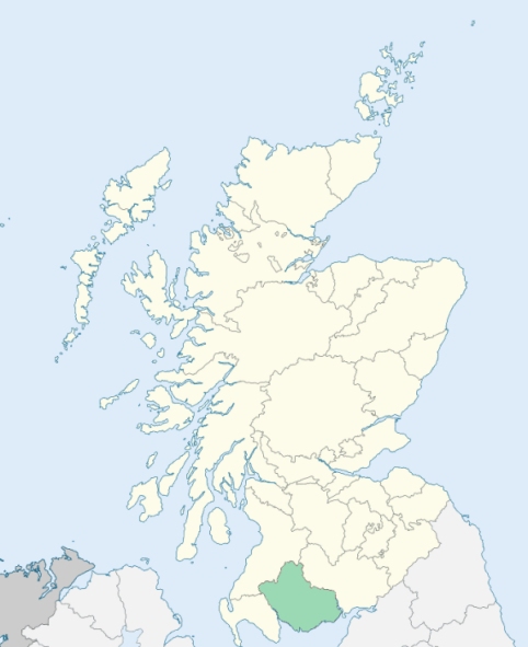
Colvend is a parish in Kirkcudbrightshire. It is bounded on the north by the parishes of Kirkgunzeon and New Abbey, on the east by the parish of Kirkbean, on the south-east, south, and south-west, by the sea, and on the west by the estuary and parish of Urr, and the parish of Kirkgunzeon. The suppressed parish of Southwick formed the eastern divison of the district. (1867: The Imperial Gazetteer of Scotland, by John Marius Wilson).
Barcloy, Barnbarroch, Boghead, Caulkerbush, Covend, Howe, Kipford or Kippford, Knockhillie or Knockhooly, Lochend, Mainsriddle, Millburnbank, Rockcliff, Southwick
Auchenskeoch
PRE-REFORMATION GOVERNANCE:
POST-REFORMATION GOVERNANCE:
Before the Reformation the church belonged to Lincluden College. There was a chapel of St Laurence in the parish at Fairgarth, where also is St Laurence's Well.
Disjoined Quoad Sacra Parishes:
Southwick. Before the Reformation the rector of Southwick held the Chancellory of the Chapel Royal of Stirling. The church was dedicated to St Mary. The parish was united to Colvend in 1612, but was disjoined again quoad sacra 13 July 1894. A church built by Sir Mark John MacTaggart-Stewart of Southwick, Bart., was opened in July 1891.
Includes ministers, licentiates, assistants, readers, and clerks.
Colvend (QO)
Southwick (QS)
(1928: Fasti Ecclesiæ Scoticanæ, by Hew Scott, D. D.)
Parish registers turned over to the Registrar-General, as a result of the Registration of Births, Deaths, and Marriages (Scotland) Act of 1854. The letters B. D. and M. indicate Births (or Baptisms), Deaths (or Burials), and Marriages (or Proclamations of Banns) respectively. Numbers indicate separate volumes or books. Note: These records are by no means complete or without damage; consult the Detailed List of the Old Parochial Registers of Scotland (1872) to learn more about the condition of the records.
| OPR and RD Numbers | |||
|---|---|---|---|
| Date Range | Name | Number | Type |
| 1781-1854 | Colvend | 861 | OPR |
| 1855-1896 | Colvend | 861 | RD |
| 1897-1968 | Colvend | 861-1 | RD |
| 1897-1968 | Southwick | 861-2 | RD |
| 1969-1971 | Castle Douglas | 861 | RD |
| 1972-2004 | Castle Douglas | 852 | RD |
| 2005-2009 | Dumfries and Galloway, Castle Douglas | 852 | RD |
| 2009 | (Colvend) Dumfries and Galloway, Dalbeattie | 864 | RD |
| 2009 | (Southwick) Dumfries and Galloway, Dalbeattie | 864 | RD |
| 2026 | (Colvend) Dumfries and Galloway Council; Colvend and Southwick Community Council | ||
| 2026 | (Southwick) Dumfries and Galloway Council; Colvend and Southwick Community Council | ||
| 2026 | (Castle Douglas) Dumfries and Galloway Council; Castle Douglas Community Council | ||
(2009: Parishes and Registration Districts of Scotland - Old and New, National Records of Scotland)
Local community councils (2026) are provided as a potential source of additional information for settlements within the original boundaries of the parish. (Source)
Statistics from informal and official censuses
Aitken, Ferguson, Halliday, Kelly, Kerr, Murdoch, Roan, Robson, Smith, Wilson
Note: Names appearing in research materials, other than censuses. Simple names (First name, surname only) have been omitted unless they appear associated with large properties. All women's names, and men's names with occupations, military ranks, or peerage titles are included.
By the Reverend Mr James Little, Minister.
"In 1772, by an epidemical malignant fever, and in 1774, by emigration, the population of this parish suffered two severe shocks, from which it hath scarcely yet recovered. Notwithstanding these circumstances, however, there has been an increase upon the whole within these 40 years. The number of inhabitants at present (1794) is 456 males, 508 females, 964 total. The return to Dr Webster, in 1755, was 898.
It is impossible to class the above inhabitants by their respective occupations. About 52 are sailors. The farms being numerous and small, many husbandmen are occasionally also masons, wrights, carpenters, shoemakers, weavers, and tailors, and one man professes two, or even three of these different mechanic branches."
(This section contains excerpts, at times restructured or paraphrased, from an article appearing in Statistical Account of Scotland, Sir John Sinclair, 1791-1799)
Primary Sources:
Statistical Account of Scotland (1791-1799), Volume 17, p. 98
New Statistical Account of Scotland (1834-1845), Volume 4, Section II, p. 373
See Parish Page Sources for all source information and links.