
Plaidwerx


Features: Scottish Parishes » Historic Shires » Orkney » Sanday

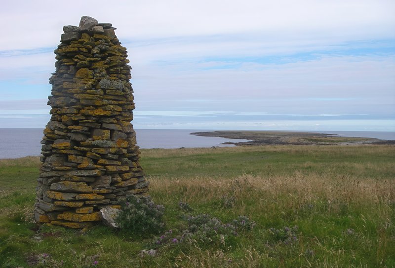
Cairn overlooking Holms of Ire, Burness, Sanday by Alan Bowring
Cairn overlooking Holms of Ire, Sanday, 2011, Alan Bowring

SANDAY PARISH

TABLE OF CONTENTS


ALTERNATE NAMES AND SPELLING:

  • Sanda (Sanday)
  • Cross and Burness (Sanday)
  • Ringansay and Sanday

LOCATION

Location Description:

Sanday is one of the most considerable of the North Isles of Orkney. It lies 2¼ miles north of Stronsay, 1½ mile east of Eday, 6¾ miles east of Westray, and 2½ miles south of North Ronaldsay. (1867: The Imperial Gazetteer of Scotland, by John Marius Wilson).

Shire, District, and Region Timeline:

  • Shire: Orkney (Before 1707)
  • County: Orkney (After 1707)
  • District: North Isles (Before 1930)
  • Landward District: Sanday (1930-1975)
  • Island Area: Orkney (1975-1996)

Cities, Towns, Villages, and Hamlets:

Braeswick, Laminess


PARISH TIMELINE

PRE-REFORMATION GOVERNANCE:

  • Diocese: Orkney

POST-REFORMATION GOVERNANCE:

  • Synod: Orkney
  • Presbytery: The North Isles

PAROCHIAL OVERVIEW:

The three parishes of Cross, Burness, and Ringansay were united in the sixteenth century. Ringansay was severed from the two others on 2 Jun 1847.
Cross. Cross, or The Cross Kirk of Sanday, was a prebend of Kirkwall. Its church was dedicated to the Holy Rood.
Burness. The church of Burness was dedicated to St Columba. Burness was a prebend of Kirkwall.

CHURCH OF SCOTLAND CLERGY:

Includes ministers, licentiates, assistants, readers, and clerks.

Lady, or Lady Kirk of Sanday (QO)

  • James Annand, 1560
  • William Brown, 1561
  • John Graham, 1567
  • Laurence Young, 1574
  • Andrew Steven, 1576
  • Alexander Cheyne, 1585
  • James Cock, 1585
  • James Stuart, 1586
  • Thomas Cock (son of James, above), 1635
  • Patrick Wemyss, 1647
  • James Douglas, 1659
  • Arthur Murray, 1660
  • Robert Birrell, 1664
  • Alexander Reid, 1666
  • James Wallace, 1668
  • Thomas Lyall, 1675
  • Patrick Guthrie, 1698
  • Thomas Keith, 1706
  • Thomas Traill, 1733
  • Thomas Lyell, 1754
  • George Dennison, 1769
  • Walter Traill, 1791
  • William Logie, 1811
  • George Smellie, 1839
  • John Anderson, 1845
  • John Dangerfield, 1863
  • John McAra, 1891
  • James Hardie Pearson, 1900
  • John Leishman Nelson, 1916
  • Henry Smith, 1919

Cross and Burness (QO)

  • William Pierson, 1560
  • Andrew Edmonston, 1605
  • Thomas Cock, 1624
  • James Haigie, 1635
  • Thomas Abercrombie, 1639
  • William Cochrane, 1657
  • James Strachan, 1676
  • Richard Mein, 1683
  • Murdoch Mackenzie, 1704
  • Thomas Covingtrie, 1711
  • James Tyrie, 1746
  • Hugh Sutherland, 1768
  • William Clouston, 1773
  • William Grant, 1794
  • Thomas Aitchison, 1845
  • Archibald Fairlie, 1854
  • Matthew Fisher, 1866
  • Alexander Morrison, 1892
  • Horace James Dick, 1901
  • John MacDougall, 1915
  • Peter John MacIver, 1919
  • David Wilson Baird, 1925

(1928: Fasti Ecclesiæ Scoticanæ, by Hew Scott, D. D.)


RECORDS

Parochial Registers:

Parish registers turned over to the Registrar-General, as a result of the Registration of Births, Deaths, and Marriages (Scotland) Act of 1854. The letters B. D. and M. indicate Births (or Baptisms), Deaths (or Burials), and Marriages (or Proclamations of Banns) respectively. Numbers indicate separate volumes or books. Note: These records are by no means complete or without damage; consult the Detailed List of the Old Parochial Registers of Scotland (1872) to learn more about the condition of the records.

  • B. 1758-1819 (Cross and Burness)
  • B. 1820-54; M. 1828-54 (Cross and Burness)
  • B. 1735-1819; M. 1818-19 (Lady)
  • B. and M. 1820-54; D. 1831-41 (Lady)

OPR and RD Numbers
Date RangeNameNumberType
1735-1854Cross and Burness26OPR
1855-1971Sanday26RD
1972-2003Sanday133RD
2009Orkney Islands, Sanday133RD
2026Orkney Islands Council; Sanday Community Council

(2009: Parishes and Registration Districts of Scotland - Old and New, National Records of Scotland)

Local community councils (2026) are provided as a potential source of additional information for settlements within the original boundaries of the parish. (Source)

Population:

Statistics from informal and official censuses

  • 1755: 750
  • 1801: 830
  • 1811: 862
  • 1821: 880
  • 1831: 858
  • 1841: 1,892 (Lady: 909; Cross and Burness: 983)
  • 1861: 2,145
  • 1881: 1,678
  • 1901: 1,727
  • 1911: 1,529

RESIDENTS


Common Surnames:

Brown, Craig, Gray

Land-owners, teachers, and other professionals:

Note: Names appearing in research materials, other than censuses. Simple names (First name, surname only) have been omitted unless they appear associated with large properties. All women's names, and men's names with occupations, military ranks, or peerage titles are included.

  • James COCK, of Westove
  • George Sholto DOUGLAS, Earl of Morton
  • James FEA, of Stove
  • Magnus FEA, of Grindilla
  • John GROAT, of Elsness
  • John IRVINE, of Isgairth
  • John MILLER, of Skelbuster
  • John SCOLLAY, of Leta
  • Malcolm SINCLAIR, of Papness
  • John SMITH, of Seater
  • Robert STEWART, of Brough
  • James TRAILL, of Houbister

Other residents:

By the Reverend Mr William Clouston.
"The people of these islands can undergo great labour and fatigue, although they are not remarkable for strength or size. It is thought they have a more florid complexion than those of the other Orkney islands, by reason of their not having fire in such plenty, and that by this they can be easily distinguished. The people, in so far as can be judged, are not remarkable for any personal or mental qualifications, but are not deficient in natural parts and sagacity. There are some few that are indolently inclined, and plead inability for hard labour; but the generality of the people are industrious, or at least laborious, as may be presumed from this circumstance, that there is no place in the county where a greater quantity of grain is raised, or kelp made, by an equal number of people. There is no manufacture carried on in these islands, unless kelp may be reckoned one. They manufacture linen and coarse cloths for their own use only."
(This section contains excerpts, at times restructured or paraphrased, from an article appearing in Statistical Account of Scotland, Sir John Sinclair, 1791-1799)


NOTES:

Primary Sources:
Statistical Account of Scotland (1791-1799), Volume 7, p. 450
New Statistical Account of Scotland (1834-1845), Volume 15, Section III, p. 133

See Parish Page Sources for all source information and links.
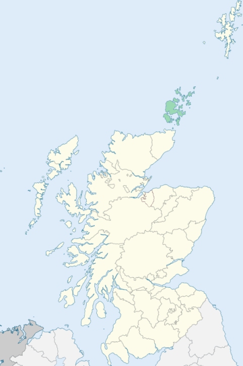

Photo credits: (Featured) Cairn overlooking Holms of Ire, Sanday, © 2011 Alan Bowring, used under Creative Commons License CC BY-SA 2.0, (Related Resources) Orkney Locator Map, © 2024, Susan Wallace, used under Creative Commons License CC BY-SA 4.0.
Related Resources
Map of Scottish highland clans and lowland families
Orkney locator map
See more maps at Wikimedia Commons
Glossary
  • Burghs:
  • Royal - Towns on royal lands
  • Regality - Towns granted to noblemen/landowners
  • Barony - Towns granted to tenant-in-chief (laird)
  • Police - Towns with elected officials
  • Small - Population under 20,000
  • Large - Population over 20,000
  •  
  • Chapel-of-Ease: Small church for those living far from the main church
  • Collegiate church: See What is a Collegiate Church?
  • Commune kirk: Owned by a larger church
  • Court of Teinds: Controlled funds for support of clergy
  •  
  • Friars:
  • Black - Dominican
  • Grey - Franciscan
  • Red - Trinitarian
  • White - Carmelite
  •  
  • Iron chapel: Building made of corrugated galvanized iron
  •  
  • Landward District: Rural part of a district
  •  
  • Mensal: Source of income to support clergy member (Roman Catholic)
  •  
  • OPR: Old Parochial Register
  •  
  • Pre-Reformation: Before 1560
  • Prebend: Source of income to support a clergy member
  •  
  • QO: Quoad Omnia - Civil and church control
  • QS: Quoad Sacra - Church control only
  •  
  • RD: Registration District - Civil control
  •  
  • Tryst: Large-scale market or fair, particularly for livestock
  •