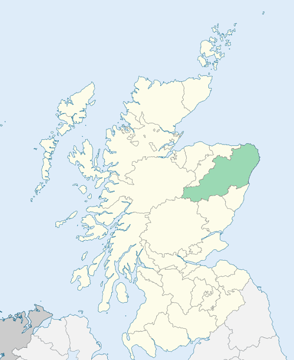
Methlick is a parish in the Buchan and Formartine districts of Aberdeenshire. The parish comprises a main body and a small detached district. The main body is bounded by New Deer, Ellon, Tarves, Fyvie, and Monquhitter. The detached district lies to the east of the main body, is separated from it by a tongue of Tarves, and is called variously Little Drumquhindle, Inverebrie, and Six Ploughs. (1867: The Imperial Gazetteer of Scotland, by John Marius Wilson).
Chapelton, Methlick
Inverebrie, Michaelmuir, Walkmill Hill
The parish of Methlick had a detached part which was bounded on the west by the parish of Tarves, and elsewhere by the parish of Ellon. This detached part was transferred to the parish of Ellon. See affected properties and landholders. (1892: Boundary of counties and parishes in Scotland as settled by the Boundary Commissioners under the Local Government Act, 1889, by Hay Shennan)
PRE-REFORMATION GOVERNANCE:
POST-REFORMATION GOVERNANCE:
The church of Methlick was dedicated to St Deavanach, and near it was St Deavanach's Well, said to possess healing virtue. Methlick was a prebend of Aberdeen. A fair of St Deavanach was held at Methlick. At Andat within the bounds there was a chapel of St Ninian, with St Ninian's Well nearby. There was another chapel at Chapelton. The old church of Methlick was built in 1780. A new church was opened on 23 April 1867.
Disjoined Quoad Sacra Parishes:
Barthol Chapel. At the place now called Barthol Chapel there was of old a chapel of St Bartholomew belonging to the Abbey of Arbroath. Mary, Countess of Aberdeen, built a church here, which opened 16 August 1875, as a memorial of her son, George, 6th Earl of Aberdeen, he having been lost at sea in 1870. His brother and successor, John, the 7th Earl, afterward first Marquess of Aberdeen and Temair, gifted a manse to the Mission, and also contributed largely towards its endowment, with the result that the Parish of Barthol Chapel was disjoined from Tarves, Fyvie, Methlick, and Meldrum, on 17 January 1876.
Includes ministers, licentiates, assistants, readers, and clerks.
Methlick (QO)
Barthol Chapel (QS)
(1928: Fasti Ecclesiæ Scoticanæ, by Hew Scott, D. D.)
Parish registers turned over to the Registrar-General, as a result of the Registration of Births, Deaths, and Marriages (Scotland) Act of 1854. The letters B. D. and M. indicate Births (or Baptisms), Deaths (or Burials), and Marriages (or Proclamations of Banns) respectively. Numbers indicate separate volumes or books. Note: These records are by no means complete or without damage; consult the Detailed List of the Old Parochial Registers of Scotland (1872) to learn more about the condition of the records.
| OPR and RD Numbers | |||
|---|---|---|---|
| Date Range | Name | Number | Type |
| 1663-1854 | Methlick | 221 | OPR |
| 1855-1967 | Methlick | 221 | RD |
| 2009 | Aberdeenshire, Turriff | 314 | RD |
| 2026 | Aberdeenshire Council; Methlick Community Council | ||
(2009: Parishes and Registration Districts of Scotland - Old and New, National Records of Scotland)
Local community councils (2026) are provided as a potential source of additional information for settlements within the original boundaries of the parish. (Source)
Statistics from informal and official censuses
Cheyne, Davidson, Duncan, Gray, Marshall, Milne, Mitchell, Moir, Simpson, Smith
Note: Names appearing in research materials, other than censuses. Simple names (First name, surname only) have been omitted unless they appear associated with large properties. All women's names, and men's names with occupations, military ranks, or peerage titles are included.
By the Reverend Mr Alexander Knolls.
"The amount of the population is about 1035. The males are 482, females 553. There are 50 farmers, 5 wrights, 5 weavers, 7 shoemakers, 4 smiths, 6 tailors, and 209 houses. There are 6 meal-mills and 2 ferry-boats.
The people are of the middle size. They are very diligent and industrious. The manufacture carried on here is that of knitting stockings, in which persons of every age and sex are employed, when other work does not interfere; this enables them to live tolerably well, and to pay their rents. They are generally frugal, more expensive in dress than in diet. They are also a social people; as one evidence of their being so, there may be sometimes 60, 70, and sometimes 100 at a wedding, to the expence of which guests contribute, by sending some milk, butter, cheese, poultry, &c. and some send stone plates and stone jugs."
(This section contains excerpts, at times restructured or paraphrased, from an article appearing in Statistical Account of Scotland, Sir John Sinclair, 1791-1799)
Primary Sources:
Statistical Account of Scotland (1791-1799), Volume 4, p. 320
New Statistical Account of Scotland (1834-1845), Volume 12, p. 962
See Parish Page Sources for all source information and links.