Kirkness
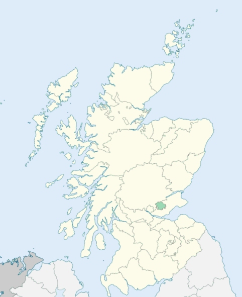
Portmoak is a parish on the east side of Kinross-shire. It lies between Loch Leven and Fife, and is bounded by the parishes of Cleish, Kinross, Orwell, Strathmiglo, Falkland, Leslie, Kinglassie, Auchterderran, and Ballingry. (1867: The Imperial Gazetteer of Scotland, by John Marius Wilson).
Bowhouse, East Balgeddie, Faill, Kinnestown, Kinnesswood, Pittendreich, Ryelaw, Scotlandwell, West Balgeddie
(1) Whereas a part of the parish of Ballingry in the county of Fife, containing 649 acres or thereby, situated at or near Wester Balbedie and adjoining the parish of Kinglassie in the county of Fife and the parish of Portmoak in the county of Kinross (being the part marked on the Ordnance Survey maps Ballingry detached No. 1), is detached from the main portion of the parish of Ballingry;
I. So much of the aforesaid detached part of the parish of Ballingry marked on the Ordnance Survey maps Ballingry detached No. 1 as is situated to the north of the centre of the new channel of the River Leven (known as The Cut) shall cease to be part of the parish of Ballingry and of the county of Fife, and shall form part of the parish of Portmoak and of the county of Kinross. See affected properties and landholders. (1892: Boundary of counties and parishes in Scotland as settled by the Boundary Commissioners under the Local Government Act, 1889, by Hay Shennan)
(2) Whereas part of the parish of Portmoak and of the county of Kinross, containing 124 acres or thereby, situated at or near the Ryelaw and adjoining the parishes of Kinglassie and Leslie in the county of Fife, is, as shown on the Ordnance Survey maps, detached from the main portion of the said parish of Portmoak and of the county of Kinross:
I. The aforesaid detached part of the parish of Portmoak and of the county of Kinross, and also those portions of the parish of Portmoak and of the county of Kinross lying to the south of and adjoining a line drawn along the centre of the new channel of the River Leven (known as The Cut), in an easterly direction from the point at which the said river enters the county of Fife until it meets the boundary of the parish of Leslie shall cease to be part of the said parish and of the said county, and shall form part of the parish of Kinglassie and of the county of Fife.
II. So much of the parish of Kinglassie and of the county of Fife as lies to the north of the line described in the preceding section shall cease to be part of that parish and of that county, and shall form part of the parish of Portmoak and of the county of Kinross.
See affected properties and landholders. (1892: Boundary of counties and parishes in Scotland as settled by the Boundary Commissioners under the Local Government Act, 1889, by Hay Shennan)
PRE-REFORMATION GOVERNANCE:
POST-REFORMATION GOVERNANCE:
The church of Kirkness was dedicated to St Moan, but there was a later dedication to St Stephen. The ancient Celtic Priory of Loch Leven was founded on St Serf's Inch in this parish in 838. King David I converted it into an Augustinian Monastery, and made it a cell of St Andrews. The parish contained also the hospital of Scotlandwell, belonging to the Red Friars. It was founded by William Malvoisine, Bishop of St Andrews, who died in 1233.
Includes ministers, licentiates, assistants, readers, and clerks.
(1928: Fasti Ecclesiæ Scoticanæ, by Hew Scott, D. D.)
Parish registers turned over to the Registrar-General, as a result of the Registration of Births, Deaths, and Marriages (Scotland) Act of 1854. The letters B. D. and M. indicate Births (or Baptisms), Deaths (or Burials), and Marriages (or Proclamations of Banns) respectively. Numbers indicate separate volumes or books. Note: These records are by no means complete or without damage; consult the Detailed List of the Old Parochial Registers of Scotland (1872) to learn more about the condition of the records.
| OPR and RD Numbers | |||
|---|---|---|---|
| Date Range | Name | Number | Type |
| 1701-1854 | Portmoak | 464 | OPR |
| 1855-1971 | Portmoak | 464 | RD |
| 2009 | Perth and Kinross, Kinross | 452 | RD |
| 2026 | Perth and Kinross Council; Portmoak Community Council | ||
(2009: Parishes and Registration Districts of Scotland - Old and New, National Records of Scotland)
Local community councils (2026) are provided as a potential source of additional information for settlements within the original boundaries of the parish. (Source)
Statistics from informal and official censuses
Arnott, Duncan, Farmer, Hay, Moore, Paterson, Scott, Thomson, Todd, Wilson
Note: Names appearing in research materials, other than censuses. Simple names (First name, surname only) have been omitted unless they appear associated with large properties. All women's names, and men's names with occupations, military ranks, or peerage titles are included.
By the Reverend Mr Andrew Grant.
"The number of souls in May 1791, was 1105. Of these there were 128 families in villages, and 133 families in the country. Of these 527 are males, and 578 females. One hundred and eighty-five married men, widowers included, have 525 children alive. In the above division of the people into professions, there are 2 parchment makers. This branch of business has been established in Kinesswood above 150 years. There are 2 villages in this parish, one of which contains 293 souls, and the other 169. The inhabitants of these are mostly tradesmen and manufacturers, many of whom are also proprietors of houses and land. In these villages there are 5 alehouses, where great quantities of spirits are sold; but as yet their bad effect on the morals of the people have not been very extensive.
The secession from the Established Church had a considerable effect, for some time, upon the temper and manners of the people in this and the neighbouring parishes. Difference of opinion, at first, not only kept them at a distance from each other, but was frequently the occasion of injuries and abuse. This violence has now disappeared, and people of different persuasions live together in the utmost harmony and peace. They are uncommonly regular in the discharge of religious duties, and, with a few exceptions, are industrious, sober, and peaceable. During the residence of the present incumbent, there is no instance of any one being punished, either by fine, banishment, or death."
(This section contains excerpts, at times restructured or paraphrased, from an article appearing in Statistical Account of Scotland, Sir John Sinclair, 1791-1799)
Primary Sources:
Statistical Account of Scotland (1791-1799), Volume 5, p. 156
New Statistical Account of Scotland (1834-1845), Volume 9, Section II, p. 30
See Parish Page Sources for all source information and links.