Fordel
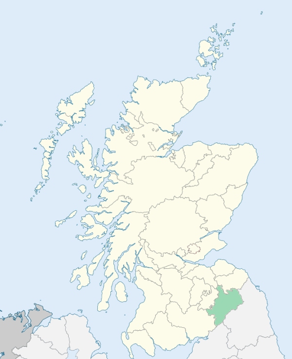
Melrose is a parish in the extreme north of Roxburghshire, forming a northerly projection of that county between Selkirkshire and Berwickshire, to the southern extremity of Edinburghshire. It is bounded by the counties of Selkirk, Edinburgh, and Berwick, and by the parishes of St Boswells, Bowden, and Lindean. (1867: The Imperial Gazetteer of Scotland, by John Marius Wilson).
Blainslee or Blainslie, Bridgend, Buckholmside, Danielstoun, Darnick, Eildon, Fordel, Gattonside, Melrose, Newstead, Newton, Newtown or Newtown St Boswells
Drygrange
(1) The parish of Earlston had a small detached part which was also a detached part of the county of Berwick, and was surrounded by the county of Roxburgh. Within the county of Berwick the parish of Lauder had a detached part situated on the west of the Leader Water and projecting into the parish of Melrose and the county of Roxburgh. Two changes were made on the county boundary:
(a) the detached part of the parish of Lauder was transferred to the parish of Melrose, and at the same time to the county of Roxburgh;
(b) so much of Earlston parish as lay to the west of the Leader Water (including the detached part) was transferred to the parish of Melrose and to the county of Roxburgh.
See affected properties and landholders. (1892: Boundary of counties and parishes in Scotland as settled by the Boundary Commissioners under the Local Government Act, 1889, by Hay Shennan)
(2) The parish of Melrose was originally situated entirely in the county of Roxburgh. By Statute, it is secured that whatever part of the parish of Melrose may be at any time included within the police limits of Galashiels, shall ipso facto become part of the county of Selkirk. A considerable portion of the parish of Melrose was thus placed within the county of Selkirk. So much of Melrose parish was situated within the county of Selkirk (i.e., so much of Melrose parish as lay within the burgh of Galashiels) was transferred to the parish of Galashiels. No change was made on the county boundary, which accordingly is the Galashiels burgh boundary along that part of its course which ran formerly through the parish of Melrose. (1892: Boundary of counties and parishes in Scotland as settled by the Boundary Commissioners under the Local Government Act, 1889, by Hay Shennan)
PRE-REFORMATION GOVERNANCE:
POST-REFORMATION GOVERNANCE:
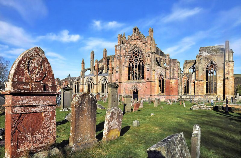
The church of Melrose, dedicated to St Cuthbert, belonged to Melrose Abbey. In the parish stood the ancient abbey of Old Melrose, founded about 650. The later Cistercian Abbey of St Mary at Melrose is also in the parish. It was founded by David I in 1136, its site being then called Fordel. There was a chapel in the parish at Gattonside, and another near Blainslie, dedicated to St Cuthbert, and known as Childhills Chapel. There were also the chapels of St Cuthbert at Old Melrose, St Columba at Columslie, and St Mary of the Park at Blainslie. A fair was held on St Martin's Day.
Includes ministers, licentiates, assistants, readers, and clerks.
Melrose (QO)
(1928: Fasti Ecclesiæ Scoticanæ, by Hew Scott, D. D.)
Parish registers turned over to the Registrar-General, as a result of the Registration of Births, Deaths, and Marriages (Scotland) Act of 1854. The letters B. D. and M. indicate Births (or Baptisms), Deaths (or Burials), and Marriages (or Proclamations of Banns) respectively. Numbers indicate separate volumes or books. Note: These records are by no means complete or without damage; consult the Detailed List of the Old Parochial Registers of Scotland (1872) to learn more about the condition of the records.
| OPR and RD Numbers | |||
|---|---|---|---|
| Date Range | Name | Number | Type |
| 1642-1854 | Melrose | 799 | OPR |
| 1855-1855 | Melrose | 799 | RD |
| 1856-1872 | Melrose | 799-1 | RD |
| 1856-1872 | Ladhope | 799-2 | RD |
| 1873-1967 | Melrose | 799-1 | RD |
| 1873-1891 | Ladhope | 776b | RD |
| 1892-1893 | Ladhope | 799-2 | RD |
| 1894-1967 | Langshaw (formerly Ladhope) | 799-2 | RD |
| 1968-1971 | Melrose | 799 | RD |
| 1972-2006 | Melrose | 820 | RD |
| 2007-2009 | (Melrose) Scottish Borders, Melrose | 820 | RD |
| 2009 | (Langshaw/Ladhope) Scottish Borders, Galashiels | 810 | RD |
| 2026 | Scottish Borders Council; Melrose and District Community Council | ||
(2009: Parishes and Registration Districts of Scotland - Old and New, National Records of Scotland)
Local community councils (2026) are provided as a potential source of additional information for settlements within the original boundaries of the parish. (Source)
Statistics from informal and official censuses
Brown, Henderson, Mitchell, Murray, Robertson, Sanderson, Scott, Smith, Thomson, Wilson
Note: Names appearing in research materials, other than censuses. Simple names (First name, surname only) have been omitted unless they appear associated with large properties. All women's names, and men's names with occupations, military ranks, or peerage titles are included.
By the Reverend Mr George Thomson.
"This parish contains at present 2446 inhabitants. There are of these, 128 Burgher Seceders , 151 Antiburghers, 53 Relief, and 18 Methodists; in all 350 Dissenters. All parties are disposed to live in peace, and to interchange the offices of good neighbourhood with one another. In so large a society, as may be expected, exceptions must be made. In general, however, the people have always been distinguished for their good sense, sobriety, and a decent and uniform attendance upon public ordinances.
Melrose has long been famed for linens, named Melrose land linens, for which commissions have been received from London and foreign countries. The woollen manufacture has of late been making considerable progress. There are 80 looms in the parish; 10 of which are employed in weaving cotton, 30 in woollen, and 30 in linen-work."
(This section contains excerpts, at times restructured or paraphrased, from an article appearing in Statistical Account of Scotland, Sir John Sinclair, 1791-1799)
Primary Sources:
Statistical Account of Scotland (1791-1799), Volume 9, p. 77
New Statistical Account of Scotland (1834-1845), Volume 3, Section I, p. 51
See Parish Page Sources for all source information and links.