
Date: Pre-1929
Boundary: District designations as they appear in early census records
Date: 1930-1975
Boundary: Landward districts were created as a result of the Local Government (Scotland) Act 1929. They were formed by grouping parishes outside of Burghs (areas known as Landward) into districts with elected councils.
Date: 1975-1996
Boundary: Region and district designations as a result of the 1973 Local Government (Scotland) Act, with OPR parishes that fell into each district. The changes took effect on 15 May 1975, and were in place until 1996.
Date: Changes made as a result of the Local Government (Scotland) Act, 1889. Changes went into effect on 15 May 1891.
Summary: Internal rearrangements. Parish of Oldhamstocks divided between Berwickshire and Haddingtonshire; Berwickshire portion to parish of Coldingham, and Haddingtonshire portion remained as Oldhamstocks. Detached portions of Lauder and Earlston were transferred to the parish of Melrose in Roxburghshire; and the detached portions of Mertoun were transferred to St Boswells in Roxburghshire.
Details:
Orders made by the Boundary Commissioners for Scotland under Section 49 of the Local Government (Scotland) Act, 1889. Orders shall come into operation for the purposes of School Board elections on the 1st day of February 1891, and for all other purposes on the 15th day of May 1891.
Affected Parishes:
Abbey St Bathans
Cockburnspath
Coldingham
Cranshaws
Earlston
Eyemouth
Hume
Lauder
Longformacus
Mertoun
Nenthorn
Oldhamstocks
Parishes of Abbey St Bathans, Cockburnspath and Longformacus, County of Berwick
The parish of Abbey St Bathans had two detached parts, one of which lay to the north of the main portion of the parish within the parish of Cockburnspath, while the other was separated from the main portion of the parish by a detached part of the parish of Longformacus. The first of these detached parts was transferred to the parish of Cockburnspath. The second of these detached parts was united with the main portion of the parish of Abbey St Bathans by the transference to that parish of the detached part of Longformacus.
Transferred from the parish of Abbey St Bathans to the parish of Cockburnspath:
Pateshill - John Turnbull of Abbey St Bathans (Proprietor)
Transferred from the parish of Longformacus to the parish of Abbey St Bathans:
Blakerstone - John Turnbull of Abbey St Bathans (Proprietor)
Parishes of Coldingham and Oldhamstocks, Counties of Berwick and Haddington
The parish of Oldhamstocks was situated partly in the county of Berwick and partly in the county of Hadddington. The Berwickshire portion was in two parts, one being a detached part of Oldhamstocks parish, and the other being part of the main portion of the parish. The detached part of the parish was transferred to the parish of Coldingham, being retained in the county of Berwick. The parish of Oldhamstocks, as thus altered in area, was then placed wholly in the county of Haddington.
Transferred from the parish of Oldhamstocks, County of Berwick to the parish of Oldhamstocks, County of Haddington:
Luckieshiel - Col. D. Milne Home of Wedderburn (Proprietor)
Monynut - Jonathan Melrose (Proprietor)
Transferred from the parish of Coldingham, County of Berwick to the parish of Eyemouth, County of Berwick:
Highlaws - Magnus Sandison of Highlaws (Proprietor)
Biglawburn - Magnus Sandison of Highlaws (Proprietor)
Transferred from the parish of Oldhamstocks, County of Berwick to the parish of Coldingham, County of Berwick:
Blackburn - Hugh Wright of Blackburn (Proprietor)
Butterdean - Right Hon. A. J. Balfour of Whittinghame (Proprietor)
Parishes of Cranshaws and Longformacus, County of Berwick
The parish of Cranshaws had one detached part which was bounded on north and east by the parish of Longformacus. An exchange of territory was effected between these parishes. The detached part of Cranshaws was transferred to Longformacus, while a portion of Longformacus was transferred to Cranshaws. The latter portion may in general terms be described as the portion of Longformacus north of the course of the River Whitadder, from the main portion of Cranshaws parish on the west to Ellem Inn on the east.
Transferred from the parish of Cranshaws, County of Berwick to the parish of Longformacus, County of Berwick:
Cranshaws (Woodlands) - A. C. Stuart of Eaglescairnie (Proprietor)
Rawburn (Farm) - A. C. Stuart of Eaglescairnie (Proprietor)
Handaxwood - Duke of Roxburghe (Proprietor)
Transferred from the parish of Longformacus, County of Berwick to the parish of Cranshaws, County of Berwick:
Ellemford - John Turnbull of Abbey St Bathans (Proprietor)
Fellcleugh - John Turnbull of Abbey St Bathans (Proprietor)
Harehead - Sir G. Grant Suttie of Prestongrange (Proprietor)
Redpath - Hon. Louisa H. Henry (Proprietor)
Smiddyhill - Earl of Wemyss & March (Proprietor)
Whitchster - Andrew Smith of Whitchester (Proprietor)
Parishes of Earlston and Lauder, County of Berwick and parish of Melrose, County of Roxburgh
The parish of Earlston had a small detached part which was also a detached part of the county of Berwick, and was surrounded by the county of Roxburgh. Within the county of Berwick the parish of Lauder had a detached part situated on the west of the Leader Water and projecting into the parish of Melrose and the county of Roxburgh. Two changes were made on the county boundary —
(a.) the detached part of the parish of Lauder was transferred to the parish of Melrose, and at the same time to the county of Roxburgh;
(b.) so much of Earlston parish as lay to the west of the Leader Water (including the detached part) was transferred to the parish of Melrose and to the county of Roxburgh.
Transferred from the parish of Lauder, County of Berwick to the parish of Melrose, County of Roxburgh:
Chapel - Henry Roberts of Chapel of Leader (Proprietor)
Chapel Mains and Chapel Parks - Henry Roberts of Chapel of Leader (Proprietor)
Bluecairn - Henry Roberts of Chapel of Leader (Proprietor)
Kedslie - Lady Reay (Proprietor)
Upper Kedslie - Lady Reay (Proprietor)
Transferred from the parish of Earlston, County of Berwick to the parish of Melrose, County of Roxburgh:
Craigsford - Captain C. Hope and Spouse (Proprietor)
Kedslie - Lady Reay (Proprietor)
Parishes of Hume and Nenthorn, County of Berwick
The parish of Hume had a detached part situated on the north-west border of the parish of Nenthorn. An exchange of territory was effected between these two parishes, whereby (a) the detached part of Hume was transferred to Nenthorn, and (b) so much of the farm of Hardiesmill Place as was situated in Nenthorn was transferred to Hume.
Transferred from the parish of Hume to the parish of Nenthorn:
Mellerstain Home Farm - Earl of Haddington (Proprietor)
Transferred from the parish of Nenthorn to the parish of Hume:
Hardie's Mill Place - George A. Baird of Stitchell (Proprietor)
Parishes of Mertoun, County of Berwick and St Boswells, County of Roxburgh
The parish of Mertoun had a part detached or nearly detached situated east of Dryburgh Abbey. This part was transferred to the parish of St Boswells and to the county of Roxburgh.
Transferred from the parish of Mertoun, County of Berwick to the parish of St Boswells, County of Roxburgh:
Bankhead - Robert Scott (Proprietor)
Coldstream
Burgh of Barony: 1621
Small Burgh: 1929
Parish: Coldstream
Region (Before 1975): Borders
District (Before 1975): Berwickshire
Duns
Burgh of Barony: 1490
Small Burgh: 1929
Parish: Duns
Region (Before 1975): Borders
District (Before 1975): Berwickshire
Eyemouth
Burgh of Barony: 1598
Small Burgh: 1929
Parish: Eyemouth
Region (Before 1975): Borders
District (Before 1975): Berwickshire
Lauder
Royal Burgh: 1502
Small Burgh: 1929
Parish: Lauder
Region (Before 1975): Borders
District (Before 1975): Ettrick and Lauderdale
See Parish Page Sources for all source information and links.
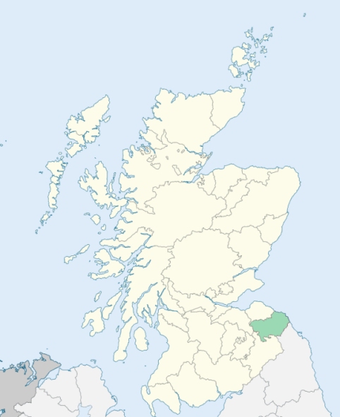
Location of Berwickshire
View more maps at Wikipedia